


|
|
|
|
|
VIP Forums Muzblog Chat Games Gallery. Форум, муздневники, чат, игры, галлерея. |
||||
|
||||||||
| Diaspora News and events in Armenian and other diasporas. |
Unseen Armenia: Hin Tagher |
LinkBack | Thread Tools | Display Modes |
 11 May 17, 17:15
|
#1 (permalink) |
|
Top VIP VIP Ultra Club

Join Date: Jan 1970
Posts: 12,055
Rep Power: 69
 |
Two villages, Hin Tagher (Taghler) and Mets Tagher (Taghler), in Artsakh’s Hadrut district, are listed in Discovering Paradise, Karabagh Guide as interesting sites featuring examples of Artsakh’s history and civil architecture. I have previously written about Mets Tagher.
 Entering Hin Tagher village (Photo: Joseph Dagdigian) Entering Hin Tagher village (Photo: Joseph Dagdigian)It was mid-afternoon when we turned off the main road onto a dirt road ascending towards the village. The sign pointing towards Hin Tagher indicated 30 km, just under 20 miles, though it seemed much longer. To our right was the slope of Dizpayt, reaching up to 1.4-1.5 miles above sea level. The slope on the other side of the road often steeply descended into valleys, some of which seemed bottomless. On two or three occasions small roads, really paths, branched to the left with small signs pointing to other villages, which we did not have time to explore. As we neared a peak in the road, we noticed the dust cloud of a red SUV trailing behind us. 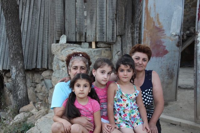 Women and children in front of Surb Amenaprkitch church, Hin Tagher (Photo: Joseph Dagdigian) Women and children in front of Surb Amenaprkitch church, Hin Tagher (Photo: Joseph Dagdigian)A monastery was initially established atop Mount Dizpayt in the 4th century and subsequently destroyed. The current structure is dated 17th century. In the village we stopped at the Surb Amenaprkitch church (ca 1400) that had recently been renovated; I’m guessing by a villager who left Armenia, became financially successful, and renovated the church for his village. Opposite the church, two women were seated with their grandchildren. Since it appeared that many of the houses had not been occupied for some time, I asked the women what the population of Hin Tagher was. “Not many” was the answer, which is frequently the response to this question in many small, remote villages. 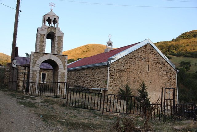 Surb Amenaprkitch church, Hin Tagher (Photo: Joseph Dagdigian) Surb Amenaprkitch church, Hin Tagher (Photo: Joseph Dagdigian)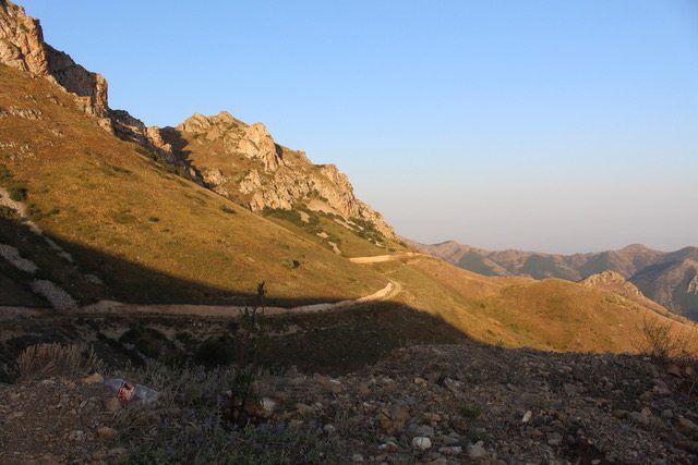 Road on Dizpayt Mountain to/from Hin Tagher (Photo: Joseph Dagdigian) Road on Dizpayt Mountain to/from Hin Tagher (Photo: Joseph Dagdigian)We spent less that an hour in the village. It was late in the afternoon and we wanted to get off the mountain before it got dark, which occurs quickly in the mountains. The two women offered us refreshments and even invited us to stay until the following morning, but we had to decline their hospitality. We were obliged to check out of our hotel in Shushi the next morning and return our rental car in Yerevan. Hopefully we’ll be able to revisit Hin Tagher. Two villages, Hin Tagher (Taghler) and Mets Tagher (Taghler), in Artsakh’s Hadrut district, are listed in Discovering Paradise, Karabagh Guide as interesting sites featuring examples of Artsakh’s history and civil architecture. I have previously written about Mets Tagher. Entering Hin Tagher village (Photo: Joseph Dagdigian) The road to Mets Tagher, though shown on our map as a secondary road, was easily passable. So, my friend and I assumed the road to Hin Tagher would be easily passable as well, neglecting the fact that the village appeared to be near the peak of Mount Dizpayt. It was mid-afternoon when we turned off the main road onto a dirt road ascending towards the village. The sign pointing towards Hin Tagher indicated 30 km, just under 20 miles, though it seemed much longer. To our right was the slope of Dizpayt, reaching up to 1.4-1.5 miles above sea level. The slope on the other side of the road often steeply descended into valleys, some of which seemed bottomless. On two or three occasions small roads, really paths, branched to the left with small signs pointing to other villages, which we did not have time to explore. As we neared a peak in [...] Two villages, Hin Tagher (Taghler) and Mets Tagher (Taghler), in Artsakh’s Hadrut district, are listed in Discovering Paradise, Karabagh Guide as interesting sites featuring examples of Artsakh’s history and civil architecture. I have previously written about Mets Tagher. Entering Hin Tagher village (Photo: Joseph Dagdigian) The road to Mets Tagher, though shown on our map as a secondary road, was easily passable. So, my friend and I assumed the road to Hin Tagher would be easily passable as well, neglecting the fact that the village appeared to be near the peak of Mount Dizpayt. It was mid-afternoon when we turned off the main road onto a dirt road ascending towards the village. The sign pointing towards Hin Tagher indicated 30 km, just under 20 miles, though it seemed much longer. To our right was the slope of Dizpayt, reaching up to 1.4-1.5 miles above sea level. The slope on the other side of the road often steeply descended into valleys, some of which seemed bottomless. On two or three occasions small roads, really paths, branched to the left with small signs pointing to other villages, which we did not have time to explore. As we neared a peak in [...] [img][/img] More... |

|

|
|
|
|
 User Control Panel


 Threaded Mode


